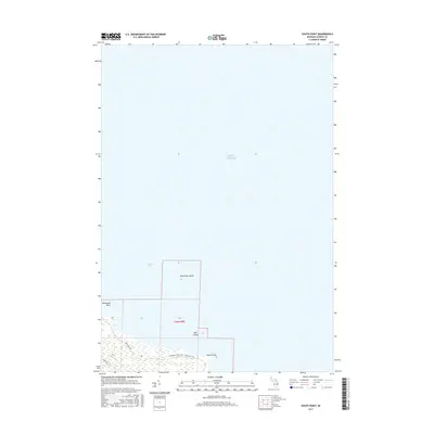
2017 Map of South Point
USGS Topo · Published 2017About this map
Lake Huron defines the vast eastern half of this coastal area, where the shoreline of Alpena County meets the open water at Thunder Bay. The land is characterized by low-lying wetlands and strategic coastal features, including the prominent projection at South Point and the sheltering landform of Hardwood Point. In the southern portion of the quadrangle, the Negwegon State Park - Algonquin Trail winds through the coastal forest, providing access to a preserved landscape that remains largely undeveloped compared to more industrial lakefronts. Just offshore, small landmasses like Scarecrow Island and Bird Island dot the bay. This 2017 survey reflects the area's modern status as a site for conservation and recreation, with local routes like Brousseau Rd and Wilds Rd serving as the primary access points to these shoreline stretches.
Find a feature on this map
11 named features on this map. Tap any name to fly to it.
Don’t see what you’re looking for? This feature index may not catch every label — zoom into the map to look around manually.
Map Details
Editions of this 2017 South Point Map
This is the sole edition of this map. No revisions or reprints were ever made.
Other maps of this area

1954 · Tawas City
USGS Topo · 1:250,000

1954 · Alpena
USGS Topo · 1:250,000

1957 · Alpena
USGS Topo · 1:250,000

1958 · Alpena
USGS Topo · 1:250,000

1958 · Tawas City
USGS Topo · 1:250,000

1969 · Alpena
USGS Topo · 1:250,000

1971 · Alpena
USGS Topo · 1:24,000
1971 · Thunder Bay Island
USGS Topo · 1:24,000

1971 · Spruce
USGS Topo · 1:24,000

1971 · North Point
USGS Topo · 1:24,000