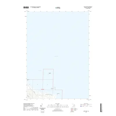
2019 Map of South Point
USGS Topo · Published 2019About this map
Negwegon State Park - Algonquin Trail occupies the coastal reaches of Sanborn Township along the shoreline of Lake Huron. This northern Michigan landscape is defined by its transition from the deep waters of Thunder Bay to the marshy, low-lying terrestrial edge of Alpena County. The map details a quiet, maritime-focused geography where landforms like South Point and Hardwood Point project into the lake, creating natural shelters for small coastal features. Off the coast, isolated landmasses such as Scarecrow Island and Bird Island sit within the vast expanse of the Great Lakes system. While most of the sheet is dominated by open water, the southwestern corner shows the beginning of local infrastructure, including Brousseau Rd and Wilds Rd, providing access to the protected parklands and the undeveloped shoreline of the t29n r9e township area.
Find a feature on this map
11 named features on this map. Tap any name to fly to it.
Don’t see what you’re looking for? This feature index may not catch every label — zoom into the map to look around manually.
Map Details
Editions of this 2019 South Point Map
This is the sole edition of this map. No revisions or reprints were ever made.
Other maps of this area

1954 · Tawas City
USGS Topo · 1:250,000

1954 · Alpena
USGS Topo · 1:250,000

1957 · Alpena
USGS Topo · 1:250,000

1958 · Alpena
USGS Topo · 1:250,000

1958 · Tawas City
USGS Topo · 1:250,000

1969 · Alpena
USGS Topo · 1:250,000

1971 · Alpena
USGS Topo · 1:24,000
1971 · Thunder Bay Island
USGS Topo · 1:24,000

1971 · Spruce
USGS Topo · 1:24,000

1971 · North Point
USGS Topo · 1:24,000