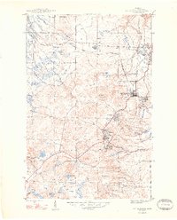
1948 Map of South Range
USGS Topo · Published 1948About this map
The copper-rich landscape of Michigan's Keweenaw Peninsula is documented here shortly after the war, centered on the industrial corridor of the Copper Range railroad. This network connects a series of mining settlements including Atlantic Mine, Trimountain, and Painesdale, where the Champion Mine and Globe Mine represent the region's deep-rooted extraction history. The map illustrates a structured landscape of industrial intent, with rail lines converging at Mill Mine Junction and residential developments like South Range and Baltic clustered near the work sites. Beyond the mine shafts and tailings, the terrain transitions into the wetlands and water bodies of Stanton and Adams townships. Water features such as Lake Perrault and the Salmon Trout River provide a natural contrast to the grid-like precision of the mining towns and the Mountain View Cem located north of the primary settlements.
Find a feature on this map
24 named features on this map. Tap any name to fly to it.
Don’t see what you’re looking for? This feature index may not catch every label — zoom into the map to look around manually.
Map Details
Editions of this 1948 South Range Map
2 editions found
Other maps of this area

1915 · Houghton
USGS Topo · 1:62,500

1946 · Hancock
USGS Topo · 1:24,000

1946 · Chassell
USGS Topo · 1:24,000

1946 · South Range
USGS Topo · 1:24,000

1948 · South Range
USGS Topo · 1:24,000

1948 · Hancock
USGS Topo · 1:24,000

1948 · Chassell
USGS Topo · 1:24,000

1954 · Graveraet River
USGS Topo · 1:24,000

1954 · Oskar
USGS Topo · 1:24,000

1954 · Beacon Hill
USGS Topo · 1:24,000