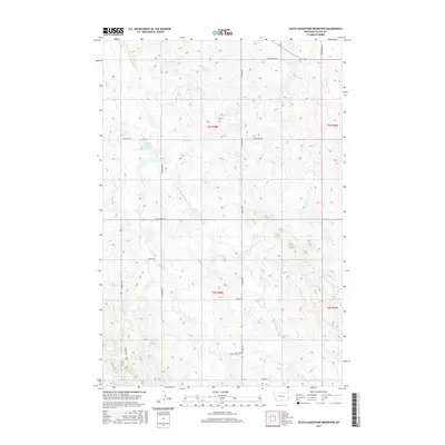
2017 Map of South Sandstone Reservoir
USGS Topo · Published 2017About this map
South Sandstone Reservoir anchors this rural Montana landscape, serving as a primary water source within the Fallon County prairie. The surrounding terrain is defined by a dendritic network of seasonal drainages, including S Fork Sandstone Cr and Coon Cr, which carve through the high plains. Human activity is marked by a grid of gravel roads and access tracks such as Reservoir Trl and Sunny Bank Rd, reflecting the expansive ranching and agricultural patterns of the region. The map details the transition from the reservoir’s edge to the higher elevations near Tower Rd, where the landscape begins to descend toward Pine Cr. Notable named thoroughfares like Calumet Rd and Green Acres Rd provide connectivity between isolated homesteads and grazing lands, illustrating the sparse but deliberate settlement structure of eastern Montana.
Find a feature on this map
19 named features on this map. Tap any name to fly to it.
Don’t see what you’re looking for? This feature index may not catch every label — zoom into the map to look around manually.
Map Details
Editions of this 2017 South Sandstone Reservoir Map
This is the sole edition of this map. No revisions or reprints were ever made.
Other maps of this area

1953 · Miles City
USGS Topo · 1:250,000

1957 · Miles City
USGS Topo · 1:250,000

1958 · Miles City
USGS Topo · 1:250,000

1981 · Baker
USGS Topo · 1:100,000

1981 · Baker NE
USGS Topo · 1:24,000

1981 · Baker
USGS Topo · 1:24,000

1981 · South Sandstone Reservoir
USGS Topo · 1:24,000

1981 · Willard
USGS Topo · 1:24,000

1981 · Little Pine Creek
USGS Topo · 1:24,000

1981 · Baker NW
USGS Topo · 1:24,000