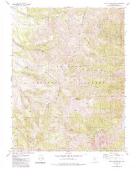
1979 Map of South Toiyabe Peak
USGS Topo · Published 1985About this map
South Toiyabe Peak stands as the central point of this high-elevation terrain within the Toiyabe National Forest. The landscape is defined by the sharp descent from the Toiyabe Range into numerous drainages, including Wisconsin Creek and the North Twin River. Evidence of historical mining activity is scattered across the slopes, with the Hamlin Mine and Murphy Mine positioned near deep canyons like Crane Canyon.
Find a feature on this map
24 named features on this map. Tap any name to fly to it.
Don’t see what you’re looking for? This feature index may not catch every label — zoom into the map to look around manually.
Map Details
Editions of this 1979 South Toiyabe Peak Map
2 editions found
Other maps of this area

1907 · Tonopah
USGS Topo · 1:250,000

1908 · Tonopah
USGS Topo · 1:250,000

1955 · Millett
USGS Topo · 1:250,000

1956 · North Shoshone Peak
USGS Topo · 1:62,500

1956 · Millett Ranch
USGS Topo · 1:62,500

1956 · Tonopah
USGS Topo · 1:250,000

1959 · Tonopah
USGS Topo · 1:250,000

1959 · Millett
USGS Topo · 1:250,000

1962 · Tonopah
USGS Topo · 1:250,000

1971 · Carvers NW
USGS Topo · 1:24,000