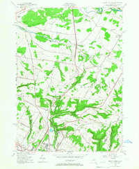
1955 Map of South Trenton
USGS Topo · Published 1967About this map
Broadacres Sanatorium and the northern outskirts of Utica anchor this mid-century look at the Oneida and Herkimer county border. The landscape is defined by the steep transition from the Mohawk Valley floor up toward the rising terrain of Marcy Hill and Bell Hill. Water management is a primary theme of the era, visible in the Utica Reservoir and the Feeder Canal which cuts across the northern terrain. Rural settlement patterns are dense with family-named roads like Morris Clark Road and Glass Factory Road, reflecting the agrarian and early industrial roots of Marcy and Deerfield. The map also captures local community centers of the 1950s, such as Salem Ch and several numbered schoolhouses like School No 16, during a period of expanding suburbanization near Deerfield Heights.
Find a feature on this map
56 named features on this map. Tap any name to fly to it.
Don’t see what you’re looking for? This feature index may not catch every label — zoom into the map to look around manually.
Map Details
Editions of this 1955 South Trenton Map
2 editions found
Other maps of this area

1895 · Oriskany
USGS Topo · 1:62,500

1897 · Remsen
USGS Topo · 1:62,500

1898 · Utica
USGS Topo · 1:62,500

1898 · Oriskany
USGS Topo · 1:62,500

1900 · Utica
USGS Topo · 1:62,500

1900 · Remsen
USGS Topo · 1:62,500

1904 · Boonville
USGS Topo · 1:62,500

1943 · Newport
USGS Topo · 1:24,000

1943 · Utica East
USGS Topo · 1:24,000
1943 · Ilion
USGS Topo · 1:24,000