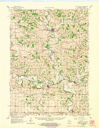
1962 Map of South Wayne
USGS Topo · Published 1964About this map
The East Branch Pecatonica River and the main Pecatonica River define the agricultural landscape of this early 1960s survey, where the river valleys dictate the placement of both settlements and rail lines. Along the southern corridor, the Chicago Milwaukee St Paul and Pacific tracks connect South Wayne and Browntown, skirting the edge of Horseshoe Lake. To the north, the village of Argyle serves as a hub at the confluence of several branches, including Dougherty Creek and Mud Branch.
Find a feature on this map
80 named features on this map. Tap any name to fly to it.
Don’t see what you’re looking for? This feature index may not catch every label — zoom into the map to look around manually.
Map Details
Editions of this 1962 South Wayne Map
This is the sole edition of this map. No revisions or reprints were ever made.
Other maps of this area

1902 · Mineral Point
USGS Topo · 1:125,000

1911 · Elizabeth
USGS Topo · 1:62,500

1920 · Monroe
USGS Topo · 1:62,500

1922 · Monroe
USGS Topo · 1:62,500

1923 · Blanchardville
USGS Topo · 1:62,500

1923 · New Glarus
USGS Topo · 1:62,500

1923 · South Wayne
USGS Topo · 1:62,500

1936 · Elizabeth
USGS Topo · 1:62,500

1937 · Lena
USGS Topo · 1:48,000

1939 · Freeport
USGS Topo · 1:48,000