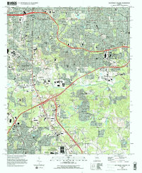
1993 Map of Southeast Atlanta
USGS Topo · Published 1995About this map
Fort Gillem Military Reservation anchors the southern portion of this landscape, reflecting the significant institutional and governmental footprint in the region during the 1990s. The map illustrates a densely structured corridor where Atlanta and East Atlanta meet the suburbs of DeKalb County, defined by a complex network of transportation and social infrastructure. Significant institutional sites such as the U S Penitentiary (Atlanta), Atlanta Correctional Center, and the Metro Correctional Institute are prominent landmarks.
Find a feature on this map
113 named features on this map. Tap any name to fly to it.
Don’t see what you’re looking for? This feature index may not catch every label — zoom into the map to look around manually.
Map Details
Editions of this 1993 Southeast Atlanta Map
This is the sole edition of this map. No revisions or reprints were ever made.
Other maps of this area

1888 · Atlanta
USGS Topo · 1:125,000

1890 · Atlanta
USGS Topo · 1:125,000

1892 · Atlanta
USGS Topo · 1:125,000

1895 · Atlanta
USGS Topo · 1:125,000

1953 · Atlanta
USGS Topo · 1:250,000

1954 · Conley
USGS Topo · 1:24,000

1954 · Decatur
USGS Topo · 1:24,000

1954 · Jonesboro
USGS Topo · 1:24,000

1954 · Riverdale
USGS Topo · 1:24,000

1954 · Bolton
USGS Topo · 1:24,000