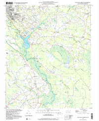
1997 Map of Southeast Lumberton
USGS Topo · Published 2000About this map
The Lumber River snakes through this Carolina landscape, anchoring a complex network of wetlands and riverine bluffs such as Matthew Bluff and Horse Bluff. This 1990s survey captures the interface of the growing city of Lumberton and the traditional agrarian communities of Bellamy and Allenton. The terrain is defined by distinctive elliptical bay features, including Warwick Mill Bay, Little Thoroughfare Bay, and Big Thoroughfare Bay, which interrupt the pine-drained flatlands.
Find a feature on this map
106 named features on this map. Tap any name to fly to it.
Don’t see what you’re looking for? This feature index may not catch every label — zoom into the map to look around manually.
Map Details
Editions of this 1997 Southeast Lumberton Map
This is the sole edition of this map. No revisions or reprints were ever made.
Other maps of this area

1943 · Pages Mill
USGS Topo · 1:62,500

1953 · Chadbourn
USGS Topo · 1:62,500

1953 · Florence
USGS Topo · 1:250,000

1954 · Florence
USGS Topo · 1:250,000

1957 · Bladenboro
USGS Topo · 1:62,500

1962 · Fairmont
USGS Topo · 1:24,000

1962 · Fair Bluff
USGS Topo · 1:62,500

1972 · Northwest Lumberton
USGS Topo · 1:24,000

1972 · Southwest Lumberton
USGS Topo · 1:24,000
1976 · Southwest Lumberton
USGS Topo · 1:24,000