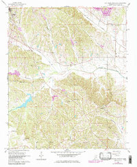
1966 Map of Southeast Pontotoc
USGS Topo · Published 1979About this map
The Old Natchez Trace Park marks the northeastern corner of this landscape, where the ancient trail meets the modern developments of the 1960s and 1970s. The terrain is defined by a dense network of waterways, including Chiwapa Creek and Tallabinnela Creek, which carve through the hilly rural countryside east of Pontotoc. This area is particularly rich in genealogical landmarks, with numerous family-named burial sites and community centers such as College Hill Cem, McCleskey Cem, and Friendship Cem.
Find a feature on this map
39 named features on this map. Tap any name to fly to it.
Don’t see what you’re looking for? This feature index may not catch every label — zoom into the map to look around manually.
Map Details
Editions of this 1966 Southeast Pontotoc Map
3 editions found
Other maps of this area

1949 · New Albany
USGS Topo · 1:62,500

1951 · New Albany
USGS Topo · 1:62,500

1955 · Sherman
USGS Topo · 1:62,500

1956 · Tupelo
USGS Topo · 1:250,000

1958 · Tupelo
USGS Topo · 1:250,000

1966 · Troy NW
USGS Topo · 1:24,000

1966 · Troy SE
USGS Topo · 1:24,000

1966 · Bissell
USGS Topo · 1:24,000

1966 · Troy
USGS Topo · 1:24,000

1972 · Houlka
USGS Topo · 1:24,000