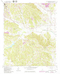
1966 Map of Southeast Pontotoc
USGS Topo · Published 1979About this map
Old Natchez Trace Parkway marks the northern boundary of this topographic study, where the historic corridor intersects a landscape defined by the winding tributaries of Chiwapa Creek. While the city of Pontotoc anchors the northwestern corner with its Pontotoc Hospital and municipal infrastructure, the remainder of the quadrangle is predominantly rural, characterized by small hilltop communities and numerous country churches. In the southeast, the small settlement of Woodland sits near the headwaters of Tallabinnela Creek. The map documents a significant density of family-named landmarks and cemeteries, such as McCluskey Cem and Edington Cem, which serve as vital markers for local genealogical research. In the south-central portion, the Troy Lookout Tower provides a high-point reference overlooking the forested creek basins and the scattered farmsteads that define this part of Pontotoc County.
Find a feature on this map
40 named features on this map. Tap any name to fly to it.
Don’t see what you’re looking for? This feature index may not catch every label — zoom into the map to look around manually.
Map Details
Editions of this 1966 Southeast Pontotoc Map
3 editions found
Other maps of this area

1949 · New Albany
USGS Topo · 1:62,500

1951 · New Albany
USGS Topo · 1:62,500

1955 · Sherman
USGS Topo · 1:62,500

1956 · Tupelo
USGS Topo · 1:250,000

1958 · Tupelo
USGS Topo · 1:250,000

1966 · Troy NW
USGS Topo · 1:24,000

1966 · Troy SE
USGS Topo · 1:24,000

1966 · Bissell
USGS Topo · 1:24,000

1966 · Troy
USGS Topo · 1:24,000

1972 · Houlka
USGS Topo · 1:24,000