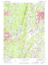
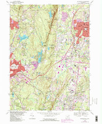
1968 Map of Southington
USGS Topo · Published 1974About this map
Southington Mountain dominates the center of this landscape, creating a dramatic physical divide between the industrial and residential growth in Southington to the east and the watershed-heavy terrain of Wolcott to the west. This mid-century survey reveals a region in transition, where late-nineteenth-century sites like the Olde Burying Ground and Wonx Spring Cem coexist with modern developments like Interstate 84 and the Tyrrell Sch Drive-in Theater. The eastern corridor is densely packed with local landmarks, including the State Reformatory in Cheshire and the Penn Central rail lines serving Milldale and Plantsville. To the west, the landscape is defined by its water resources, from the recreational waters of Hitchcock Lake to the vital storage of Southington Reservoir No. 1 and the Scovill Reservoir. The detailed mapping of local schools like Alcott Sch and Beecher Street Sch provides excellent ground-truth for those researching family history in the New Haven and Hartford county borderlands.
Find a feature on this map
98 named features on this map. Tap any name to fly to it.
Don’t see what you’re looking for? This feature index may not catch every label — zoom into the map to look around manually.
Map Details
Editions of this 1968 Southington Map
5 editions found
Other maps of this area

1889 · Derby
USGS Topo · 1:62,500

1891 · Derby
USGS Topo · 1:62,500

1892 · New Haven
USGS Topo · 1:62,500

1892 · Meriden
USGS Topo · 1:62,500

1893 · Waterbury
USGS Topo · 1:62,500

1893 · Meriden
USGS Topo · 1:62,500

1893 · Derby
USGS Topo · 1:62,500

1904 · Waterbury
USGS Topo · 1:62,500

1904 · Litchfield
USGS Topo · 1:125,000

1906 · Farmington
USGS Topo · 1:125,000