
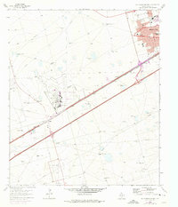
1965 Map of Southwest Midland
USGS Topo · Published 1966About this map
Midland expansion in the mid-1960s is defined here by the intersection of aviation, petroleum, and education. The Midland Air Terminal stands as a central hub of activity, supported by the neighboring Terminal Ch and industrial infrastructure like the Sewage Disposal plant. This era of growth is further evidenced by a concentration of new schools including Alamo Jr High Sch, Jane Long Sch, and Anson Jones Sch, reflecting the postwar suburbanization of the Permian Basin.
Find a feature on this map
28 named features on this map. Tap any name to fly to it.
Don’t see what you’re looking for? This feature index may not catch every label — zoom into the map to look around manually.
Map Details
Editions of this 1965 Southwest Midland Map
2 editions found
Other maps of this area

1954 · Hobbs
USGS Topo · 1:250,000

1954 · Pecos
USGS Topo · 1:250,000

1957 · Pecos
USGS Topo · 1:250,000

1958 · Hobbs
USGS Topo · 1:250,000

1964 · Bryant Ranch
USGS Topo · 1:24,000

1964 · Odessa NE
USGS Topo · 1:24,000

1964 · Odessa SE
USGS Topo · 1:24,000

1964 · Parks
USGS Topo · 1:24,000

1965 · Southeast Midland
USGS Topo · 1:24,000

1965 · Northeast Midland
USGS Topo · 1:24,000