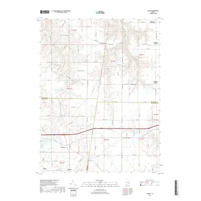
2019 Map of Spades
USGS Topo · Published 2019About this map
Sunman and St. Leon anchor this 2019 survey of the undulating landscape where Ripley, Dearborn, and Franklin Counties meet. The area is characterized by a dense network of country roads and scattered rural settlements like Penntown and Lawrenceville, illustrating the long-standing agricultural and residential patterns of southeastern Indiana. Natural drainages such as Blue Creek, Pipe Creek, and Turkey Run carve through the terrain, while landmarks like Horseshoe Bend and Wayne Kopp Lake break the grid of section lines. Genealogists and local historians can locate smaller burial grounds including Usher Cem and Alden Cem, alongside named intersections such as Klemmes Corner, Youngs Corner, and Oak Tree Crossroads that have served as local community nodes for generations. The map provides a contemporary view of these established townships, from the clusters of Saint Peter and Highland Center to the rail-aligned town of Spades in the southwest.
Find a feature on this map
109 named features on this map. Tap any name to fly to it.
Don’t see what you’re looking for? This feature index may not catch every label — zoom into the map to look around manually.
Map Details
Editions of this 2019 Spades Map
This is the sole edition of this map. No revisions or reprints were ever made.
Other maps of this area

1915 · Lawrenceburg
USGS Topo · 1:48,000

1915 · Harrison
USGS Topo · 1:48,000

1928 · Lawrenceburg
USGS Topo · 1:62,500

1932 · Lawrenceburg
USGS Topo · 1:62,500

1943 · Guilford
USGS Topo · 1:24,000

1946 · Pierceville
USGS Topo · 1:24,000

1946 · Batesville
USGS Topo · 1:24,000

1953 · Guilford
USGS Topo · 1:24,000

1953 · Cincinnati
USGS Topo · 1:250,000

1955 · Mount Carmel
USGS Topo · 1:24,000