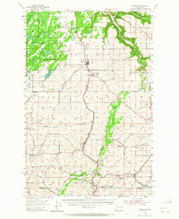
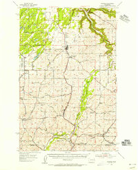
1954 Map of Spangle
USGS Topo · Published 1965About this map
Spangle serves as the central hub of this eastern Washington landscape, situated along the Northern Pacific railroad and Inland Empire Way. The 1950s geography reveals a transition from the marshy western margins of the Turnbull National Wildlife Refuge, featuring Philleo Lake, to the rolling agricultural lands of the Palouse. Settlement patterns are tied closely to the rail corridors, with small communities like North Pine, Plaza, and Spring Valley marking the intersections of local commerce and transport. The map provides a clear record of local institutions, from the Upper Columbia Academy to former community centers like the Buckeye Sch and Prairie View Sch. Along the eastern edge, the drainage of Latah Creek winds through the terrain, while numerous family-named roads such as Babbs Road and Rohwer Rd offer a primary resource for tracing regional genealogy and property history.
Find a feature on this map
60 named features on this map. Tap any name to fly to it.
Don’t see what you’re looking for? This feature index may not catch every label — zoom into the map to look around manually.
Map Details
Editions of this 1954 Spangle Map
2 editions found
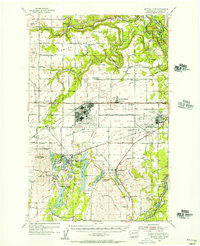
Other maps of this area

1901 · Spokane
USGS Topo · 1:125,000

1903 · Oakesdale
USGS Topo · 1:125,000

1905 · Oakesdale
USGS Topo · 1:125,000

1943 · Medical Lake
USGS Topo · 1:62,500

1949 · Greenacres
USGS Topo · 1:62,500
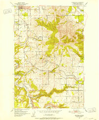
1950 · Spokane SE
USGS Topo · 1:24,000

1950 · Spokane SW
USGS Topo · 1:24,000

1950 · Spokane
USGS Topo · 1:62,500

1951 · Greenacres
USGS Topo · 1:62,500
1954 · Medical Lake
USGS Topo · 1:62,500