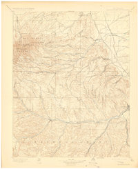
1897 Map of Spanish Peaks
USGS Topo · Published 1923About this map
East Spanish Peak and West Spanish Peak dominate the northwestern horizon of this 1895 survey, casting long shadows over the complex network of canyons and coal-related settlements in southern Colorado. The landscape is defined by the transition from the high elevations of the San Isabel National Forest down into the valleys of the Apishapa River and the Purgatoire River. This era shows a flourishing coal mining and rail economy, with the Denver and Rio Grande RR Trinidad Line and the Colorado and Southern RR serving essential industrial hubs like Ludlow, Hastings, and Berwind. Cultural history is deeply etched into the map through numerous Hispanic plazas and settlements such as Trujillo Plaza and Martinez Plaza, alongside the expansive southern reach of the Maxwell Grant. From the post office at Theras (Madrid P.O.) to the company towns of Sopris and Starkville, the map reveals a meticulously documented world of high-altitude industry and frontier community life.
Find a feature on this map
84 named features on this map. Tap any name to fly to it.
Don’t see what you’re looking for? This feature index may not catch every label — zoom into the map to look around manually.
Map Details
Editions of this 1897 Spanish Peaks Map
5 editions found

Other maps of this area

1889 · Huerfano Park
USGS Topo · 1:125,000

1891 · Walsenburg
USGS Topo · 1:125,000

1891 · Spanish Peaks
USGS Topo · 1:125,000

1891 · Apishapa
USGS Topo · 1:125,000

1892 · Huerfano Park
USGS Topo · 1:125,000

1892 · Elmoro
USGS Topo · 1:125,000

1893 · Spanish Peaks
USGS Topo · 1:125,000

1893 · Apishapa
USGS Topo · 1:125,000

1893 · Elmoro
USGS Topo · 1:125,000

1894 · Walsenburg
USGS Topo · 1:125,000