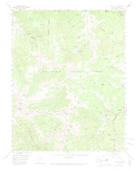
1957 Map of Spar City
USGS Topo · Published 1974About this map
Spar City and the surrounding high-altitude terrain of the Rio Grande National Forest are defined by the legacies of late 19th-century silver mining and the rugged geography of the San Juan Mountains. This 1957 field-checked survey captures a landscape where industry and conservation meet, featuring the Denver Tunnel and Emma Mine situated near Monument Peak. The map follows the high ridges of the Continental Divide, marking the boundary between the Rio Grande and San Juan National Forest.
Find a feature on this map
77 named features on this map. Tap any name to fly to it.
Don’t see what you’re looking for? This feature index may not catch every label — zoom into the map to look around manually.
Map Details
Editions of this 1957 Spar City Map
5 editions found

Other maps of this area

1905 · San Cristobal
USGS Topo · 1:125,000

1907 · San Cristobal
USGS Topo · 1:125,000

1913 · Summitville
USGS Topo · 1:125,000

1914 · Creede
USGS Topo · 1:125,000

1915 · Summitville
USGS Topo · 1:125,000

1916 · Creede
USGS Topo · 1:125,000

1924 · Pagosa Springs
USGS Topo · 1:125,000

1927 · Pagosa Springs
USGS Topo · 1:125,000

1945 · Durango
USGS Topo · 1:250,000

1953 · Durango
USGS Topo · 1:250,000