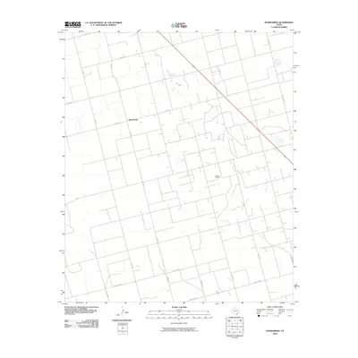
2010 Map of Sparenberg
USGS Topo · Published 2010About this map
The settlement of Sparenberg sits at a rural crossroads in Dawson County, where the landscape is defined by a dense grid of section roads and the infrastructure of the West Texas petroleum industry. This 2010 survey highlights the Ackerly Oil Field, which occupies a significant portion of the eastern quadrangle, marked by numerous well pads and service tracks. The transportation network is built upon a precise lattice of county roads, including Co Rd 29 and Co Rd 30, alongside state-maintained routes like Farm Rd 26 and Ranch Rd 178. This map serves as an essential record of the modern energy landscape, capturing the intersection of agricultural land divisions and active oil extraction during the early 21st century.
Find a feature on this map
17 named features on this map. Tap any name to fly to it.
Don’t see what you’re looking for? This feature index may not catch every label — zoom into the map to look around manually.
Map Details
Editions of this 2010 Sparenberg Map
This is the sole edition of this map. No revisions or reprints were ever made.
Other maps of this area

1954 · Big Spring
USGS Topo · 1:250,000

1958 · Big Spring
USGS Topo · 1:250,000

1966 · Knott
USGS Topo · 1:24,000

1966 · Merrick
USGS Topo · 1:24,000

1966 · Flower Grove
USGS Topo · 1:24,000

1970 · Lamesa South
USGS Topo · 1:24,000

1970 · Ackerly
USGS Topo · 1:24,000

1970 · Key
USGS Topo · 1:24,000
1970 · Tenmile
USGS Topo · 1:24,000

1970 · Sand Creek
USGS Topo · 1:24,000