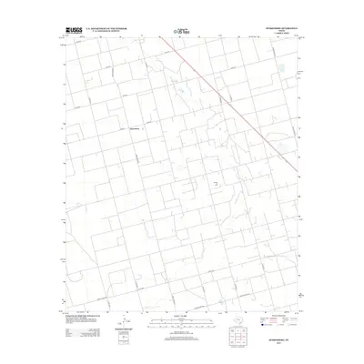
2012 Map of Sparenberg
USGS Topo · Published 2012About this map
Sparenberg sits at the heart of this West Texas landscape, serving as a focal point for a vast network of county and ranch roads. The geometry of the land is defined by a rigid grid of agricultural and industrial access routes, reflecting the region's dual reliance on ranching and energy extraction. A significant portion of the southeastern quadrant is occupied by the Ackerly Oil Field, indicating the subsurface wealth that has shaped the local economy. Beyond the primary thoroughfares like Ranch Road 26 and Ranch Road 2002, a dense web of smaller tracks including Co Rd-29 and Co Rd-27 provide access to the expansive sections of Dawson County. The terrain is marked by subtle depressions and drainage patterns that contrast with the linear precision of the man-made infrastructure.
Find a feature on this map
19 named features on this map. Tap any name to fly to it.
Don’t see what you’re looking for? This feature index may not catch every label — zoom into the map to look around manually.
Map Details
Editions of this 2012 Sparenberg Map
This is the sole edition of this map. No revisions or reprints were ever made.
Other maps of this area

1954 · Big Spring
USGS Topo · 1:250,000

1958 · Big Spring
USGS Topo · 1:250,000

1966 · Knott
USGS Topo · 1:24,000

1966 · Merrick
USGS Topo · 1:24,000

1966 · Flower Grove
USGS Topo · 1:24,000

1970 · Lamesa South
USGS Topo · 1:24,000

1970 · Ackerly
USGS Topo · 1:24,000

1970 · Key
USGS Topo · 1:24,000
1970 · Tenmile
USGS Topo · 1:24,000

1970 · Sand Creek
USGS Topo · 1:24,000