
2016 Map of Sparenberg
USGS Topo · Published 2016About this map
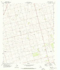
Sparenberg serves as the primary focal point of this West Texas landscape, situated within a grid of rural roads that define the region's agricultural character. This 2016 survey illustrates the organized land partitioning typical of the Llano Estacado, where gravel and paved routes like Co Rd 29 and Co Rd 30 facilitate transport across the plains. The most significant natural feature is Sulphur Springs Draw, which meanders across the southern portion of the map, providing a topographical break in the otherwise steady elevation. The southern boundary marks the transition between Dawson Co and Martin Co, a line traced by Co Rd 34 and Farm Rd 2002-E. This map captures the modern infrastructure of a deep-rooted farming community, documenting the exact placement of local connectors such as Co Rd 4700 and Co Rd 3901 as they serve the scattered farmsteads of the high plains.
Find a feature on this map
36 named features on this map. Tap any name to fly to it.
Don’t see what you’re looking for? This feature index may not catch every label — zoom into the map to look around manually.
Map Details
Editions of this 2016 Sparenberg Map
This is the sole edition of this map. No revisions or reprints were ever made.
Other maps of this area

1954 · Big Spring
USGS Topo · 1:250,000

1958 · Big Spring
USGS Topo · 1:250,000

1966 · Knott
USGS Topo · 1:24,000

1966 · Merrick
USGS Topo · 1:24,000

1966 · Flower Grove
USGS Topo · 1:24,000

1970 · Lamesa South
USGS Topo · 1:24,000

1970 · Ackerly
USGS Topo · 1:24,000

1970 · Key
USGS Topo · 1:24,000
1970 · Tenmile
USGS Topo · 1:24,000

1970 · Sand Creek
USGS Topo · 1:24,000