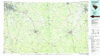
1986 Map of Spartanburg
USGS Topo · Published 1986About this map
Spartanburg serves as the industrial and academic anchor of the Piedmont in the mid-1980s, connected to the wider region by the intersection of I-85 and I-26. The urban core is surrounded by historic mill towns like Glendale and Arkwright, while the Univ of S C Spartanburg and the Downtown Memorial Airport mark the city's modern growth. To the south and east, the landscape transitions into the heavily wooded expanse of the Sumter National Forest and the conserved grounds of Croft State Park, once a significant military training site at Camp Croft.
Find a feature on this map
164 named features on this map. Tap any name to fly to it.
Don’t see what you’re looking for? This feature index may not catch every label — zoom into the map to look around manually.
Map Details
Editions of this 1986 Spartanburg Map
2 editions found
Other maps of this area

1892 · Abbeville
USGS Topo · 1:125,000

1904 · Columbia
USGS Topo · 1:125,000

1905 · Charlotte
USGS Topo · 1:48,000

1906 · Kings Mountain
USGS Topo · 1:62,500

1907 · Sharon
USGS Topo · 1:62,500

1907 · Saluda
USGS Topo · 1:125,000

1907 · Charlotte
USGS Topo · 1:62,500

1908 · Kings Mountain
USGS Topo · 1:62,500

1909 · Gaffney
USGS Topo · 1:62,500

1935 · Greer
USGS Topo · 1:48,000