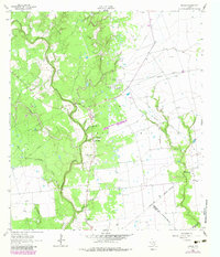
1964 Map of Speaks
USGS Topo · Published 1983About this map
The Navidad River and its numerous tributaries, such as Sandy Creek and Peach Creek, define this mid-1960s landscape in Lavaca County. The region is characterized by a transition from the wooded bottomlands along the river to the open spaces of the Provident City Gas Field. This industrial presence is marked by infrastructure like the Wilcox Refinery, a Provident City Refinery, and numerous gas wells scattered across the eastern plains.
Find a feature on this map
28 named features on this map. Tap any name to fly to it.
Don’t see what you’re looking for? This feature index may not catch every label — zoom into the map to look around manually.
Map Details
Editions of this 1964 Speaks Map
2 editions found
Other maps of this area

1953 · Seguin
USGS Topo · 1:250,000

1958 · Seguin
USGS Topo · 1:250,000

1962 · Sublime
USGS Topo · 1:24,000

1962 · Hallettsville SE
USGS Topo · 1:24,000

1964 · Cordele
USGS Topo · 1:24,000

1964 · Morales
USGS Topo · 1:24,000

1964 · Speaks
USGS Topo · 1:24,000
1965 · Sheridan NE
USGS Topo · 1:24,000

1965 · Ganado NE
USGS Topo · 1:24,000

1965 · Sheridan SE
USGS Topo · 1:24,000