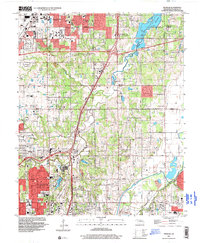
1995 Map of Spencer
USGS Topo · Published 1999About this map
National Cowboy Hall of Fame stands as a prominent cultural anchor in this mid-1990s portrait of the growing northeast suburbs of Oklahoma City. The map illustrates a landscape of institutional expansion and residential development, bounded by the North Canadian River and the Deep Fork of the Canadian River. Academic and community hubs are well-represented, including Oklahoma Christian College, Midwest Christian College, and several local schools like Cimarron Middle Sch. The region's transport network is defined by the Turner Turnpike and the tracks of the Midwest and Oklahoma City RR. Numerous oil wells scattered across the terrain point to the area's ongoing industrial heritage, while established community spaces like Springlake Park, Twin Hills Country Club, and the Arlington Memorial Park Cemetery provide a sense of local history and permanence.
Find a feature on this map
52 named features on this map. Tap any name to fly to it.
Don’t see what you’re looking for? This feature index may not catch every label — zoom into the map to look around manually.
Map Details
Editions of this 1995 Spencer Map
This is the sole edition of this map. No revisions or reprints were ever made.
Other maps of this area

1892 · Moore
USGS Topo · 1:62,500

1892 · Edmond
USGS Topo · 1:62,500

1892 · Kingfisher
USGS Topo · 1:125,000

1893 · Oklahoma City
USGS Topo · 1:62,500

1895 · Kingfisher
USGS Topo · 1:125,000

1898 · Purcell
USGS Topo · 1:125,000

1904 · Chickasha
USGS Topo · 1:125,000

1934 · Crutcho Creek
USGS Topo · 1:24,000

1934 · Moore
USGS Topo · 1:62,500

1935 · Spencer
USGS Topo · 1:24,000