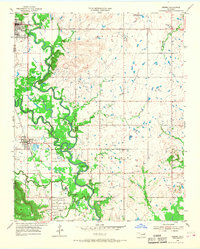
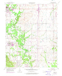
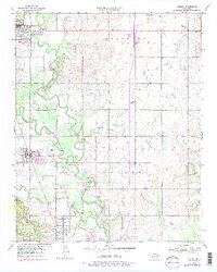
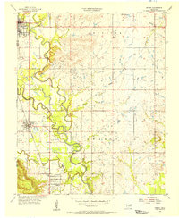
1955 Map of Sperry
USGS Topo · Published 1968About this map
Bird Creek and Hominy Creek converge in this mid-century landscape, carving a winding path through the borderlands of Osage and Tulsa counties. The area is defined by its transition from agricultural bottomlands to an active energy and industrial corridor, evidenced by numerous oil wells and the Midland Valley railroad line. Small settlements like Skiatook, Sperry, and Turley serve as local hubs, while cultural landmarks like the Drive-in Theater and a Racetrack point to the era's recreational development. Genealogists will find significant value in the distribution of local burial sites, including Skiatook Cem, Charley Cem, Chisholm Cem, and Crown Hill Cemetery, which reflect the long-standing family ties and communities of the region.
Find a feature on this map
27 named features on this map. Tap any name to fly to it.
Don’t see what you’re looking for? This feature index may not catch every label — zoom into the map to look around manually.
Map Details
Editions of this 1955 Sperry Map
4 editions found
Other maps of this area

1901 · Claremore
USGS Topo · 1:125,000

1912 · Hominy
USGS Topo · 1:125,000

1914 · Claremore
USGS Topo · 1:125,000

1915 · Hominy
USGS Topo · 1:125,000

1916 · Claremore
USGS Topo · 1:125,000

1954 · Tulsa
USGS Topo · 1:250,000

1954 · Tulsa
USGS Topo · 1:24,000
1955 · Sperry
USGS Topo · 1:24,000

1955 · Mingo
USGS Topo · 1:24,000

1955 · Enid
USGS Topo · 1:250,000