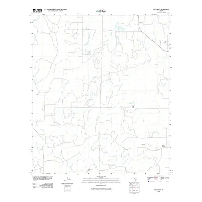
2010 Map of Spice Rock
USGS Topo · Published 2010About this map
The San Saba River defines the northern edge of this landscape, where the waterways of McCulloch County converge in a network of seasonal draws and creeks. This 2010 survey illustrates a rural ranching environment characterized by prominent geological landmarks such as Flat Rock and the granite outcrop of Spy Rock. The drainage patterns are clearly delineated, with Tiger Creek, Katemcy Creek, and Spice Creek carving through the terrain. Evidence of the area's long-term settlement is found in several historic burial grounds, including Blackjack Cemetery and Wagram Cemetery in the southeast. Modern infrastructure is limited to a sparse network of ranch roads and the small, private Polk Ranch Airport, reflecting a region where the land remains dedicated to traditional agricultural use and open space.
Find a feature on this map
37 named features on this map. Tap any name to fly to it.
Don’t see what you’re looking for? This feature index may not catch every label — zoom into the map to look around manually.
Map Details
Editions of this 2010 Spice Rock Map
This is the sole edition of this map. No revisions or reprints were ever made.
Other maps of this area

1887 · Mason
USGS Topo · 1:125,000

1894 · Brady
USGS Topo · 1:125,000

1894 · Mason
USGS Topo · 1:125,000

1954 · Brownwood
USGS Topo · 1:250,000

1954 · Llano
USGS Topo · 1:250,000

1955 · Llano
USGS Topo · 1:250,000

1956 · Llano
USGS Topo · 1:250,000

1962 · Purdy Hill
USGS Topo · 1:24,000
1962 · Fly Gap
USGS Topo · 1:24,000
1962 · Fredonia
USGS Topo · 1:24,000