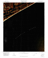
1980 Map of Spicer Bay
USGS Topo · Published 1985About this map
The coastal waters of Onslow County are captured in this 1980 infrared orthophotoquad, showing the intricate relationship between the mainland and the barrier islands. Thomas Landing serves as a primary reference point for the maritime landscape, overlooking the expansive waters of Stump Sound. The map highlights the complex network of inlets and sheltered waters including Spicer Bay and Everett Bay, which are separated from the Atlantic Ocean by thin strips of sand and marsh. This imagery provides a clear view of the undeveloped character of Ashe Island and the surrounding wetlands before modern development intensified. The infrared photography specifically emphasizes the contrast between the dense vegetation of the coastal forests and the tidal flats that define this stretch of the North Carolina shoreline.
Find a feature on this map
6 named features on this map. Tap any name to fly to it.
Don’t see what you’re looking for? This feature index may not catch every label — zoom into the map to look around manually.
Map Details
Editions of this 1980 Spicer Bay Map
2 editions found
Other maps of this area

1942 · Spicer Bay
USGS Topo · 1:62,500

1942 · Topsail
USGS Topo · 1:62,500

1948 · Maple Hill
USGS Topo · 1:62,500

1948 · Topsail
USGS Topo · 1:62,500

1948 · New River
USGS Topo · 1:62,500

1952 · Spicer Bay
USGS Topo · 1:24,000

1952 · New River Inlet
USGS Topo · 1:24,000

1952 · Sneads Ferry
USGS Topo · 1:24,000

1953 · Beaufort
USGS Topo · 1:250,000

1954 · Beaufort
USGS Topo · 1:250,000
Featured Places
- Holly Ridge, NC
- North Topsail Beach, NC
- Thomas Landing, NC
- Ocean City Beach, North Topsail Beach
- Onslow County, NC