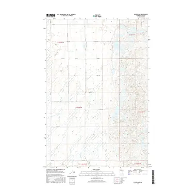
2016 Map of Spider Lake
USGS Topo · Published 2016About this map
Spider Lake and its surrounding wetlands dominate this landscape in Cass County, where glacial geology has left a dense network of water bodies. The terrain is defined by a complex mosaic of lakes and drainage systems, including Beaver Cr which snakes through the western portion of the quadrangle. A systematic grid of county and local roads, such as Co HWY 2 and Co RD 111, provides access to the scattered shorelines and forested tracts. Smaller bodies of water like Deer Lake, Mink Lake, and Taylor Lake are clustered to the east, illustrating the kettle-hole topography typical of this Minnesota region. The map captures the area as a recreational and residential corridor where the land use is heavily influenced by the presence of significant aquatic features like Goose Lake and Cut Lake.
Find a feature on this map
37 named features on this map. Tap any name to fly to it.
Don’t see what you’re looking for? This feature index may not catch every label — zoom into the map to look around manually.
Map Details
Editions of this 2016 Spider Lake Map
This is the sole edition of this map. No revisions or reprints were ever made.
Other maps of this area

1919 · Leader
USGS Topo · 1:62,500

1953 · Brainerd
USGS Topo · 1:250,000

1957 · Brainerd
USGS Topo · 1:250,000

1958 · Brainerd
USGS Topo · 1:250,000

1965 · Brainerd
USGS Topo · 1:250,000

1969 · Burgen Lake
USGS Topo · 1:24,000
1969 · Oylen
USGS Topo · 1:24,000

1970 · Spider Lake
USGS Topo · 1:24,000

1970 · Backus
USGS Topo · 1:24,000
1970 · Bungo Creek
USGS Topo · 1:24,000