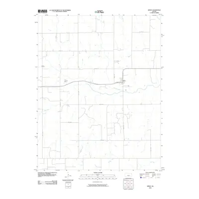
2009 Map of Spivey
USGS Topo · Published 2009About this map
Spivey serves as the primary hub of this Kingman County landscape, situated at the intersection of N Main St and W Stanley Ave. The surrounding terrain is defined by an orderly grid of agricultural section roads, occasionally interrupted by the meandering paths of Wild Horse Creek and Sand Creek. The map documents a rural Kansas environment where aviation and agriculture intersect, notably at the Dick Landing Strip west of the town center.
Find a feature on this map
23 named features on this map. Tap any name to fly to it.
Don’t see what you’re looking for? This feature index may not catch every label — zoom into the map to look around manually.
Map Details
Editions of this 2009 Spivey Map
This is the sole edition of this map. No revisions or reprints were ever made.
Other maps of this area

1889 · Anthony
USGS Topo · 1:125,000

1891 · Anthony
USGS Topo · 1:125,000

1892 · Kingman
USGS Topo · 1:125,000

1894 · Kingman
USGS Topo · 1:125,000

1955 · Pratt
USGS Topo · 1:250,000

1959 · Pratt
USGS Topo · 1:250,000
1967 · Alameda
USGS Topo · 1:24,000

1967 · Cleveland
USGS Topo · 1:24,000
1967 · Willowdale
USGS Topo · 1:24,000
1973 · Spivey
USGS Topo · 1:24,000