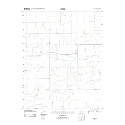
2012 Map of Spivey
USGS Topo · Published 2012About this map
Wild Horse Creek and Sand Creek cut through this section of south-central Kansas, where a rigid grid of section roads defines the agricultural landscape. The small community of Spivey centers around the intersection of S Main St and Sloan Avenue, featuring a local Post Office that serves the surrounding rural households. This 2012 survey illustrates the continued importance of local aviation and family heritage in the region, noting the Dick Airport situated just north of the main east-west highway and the Nichols Cemetery positioned on the western edge of the map. The drainage patterns of Red Creek in the northeast corner reveal the subtle topography that influences the placement of farmsteads across Kingman County.
Find a feature on this map
30 named features on this map. Tap any name to fly to it.
Don’t see what you’re looking for? This feature index may not catch every label — zoom into the map to look around manually.
Map Details
Editions of this 2012 Spivey Map
This is the sole edition of this map. No revisions or reprints were ever made.
Other maps of this area

1889 · Anthony
USGS Topo · 1:125,000

1891 · Anthony
USGS Topo · 1:125,000

1892 · Kingman
USGS Topo · 1:125,000

1894 · Kingman
USGS Topo · 1:125,000

1955 · Pratt
USGS Topo · 1:250,000

1959 · Pratt
USGS Topo · 1:250,000
1967 · Alameda
USGS Topo · 1:24,000

1967 · Cleveland
USGS Topo · 1:24,000
1967 · Willowdale
USGS Topo · 1:24,000
1973 · Spivey
USGS Topo · 1:24,000