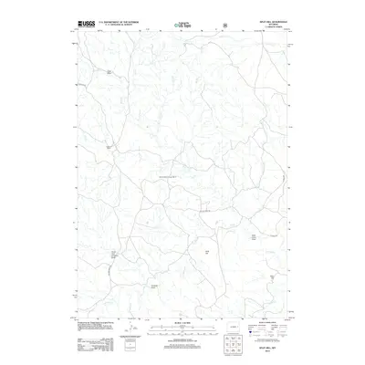
2012 Map of Split Hill
USGS Topo · Published 2012About this map
Ketelson Ranch and several family-named landmarks define this central Wyoming landscape, where the drainage patterns of Lightning Cr and Piney Cr dictate the layout of ranching operations. The terrain is marked by distinctive elevations such as Split Hill and Cake Hill, alongside several significant drainage features like Coal Draw and John Henry Draw. Remote access is facilitated by a network of rural routes, including Walker Creek Rd and USFS 959 Rd. The inclusion of the Iberlin Ranch Airport Nr 3 underscores the vast distances and logistical requirements of managing livestock in Converse County. The map provides a detailed view of the complex water management system through numerous labeled intermittent streams like Owl Cr, Dry Cr, and Little Cow Cr, which are vital to the region's agricultural viability.
Find a feature on this map
20 named features on this map. Tap any name to fly to it.
Don’t see what you’re looking for? This feature index may not catch every label — zoom into the map to look around manually.
Map Details
Editions of this 2012 Split Hill Map
This is the sole edition of this map. No revisions or reprints were ever made.
Other maps of this area

1955 · Newcastle
USGS Topo · 1:250,000

1958 · Newcastle
USGS Topo · 1:250,000

1970 · Bill 4 SE
USGS Topo · 1:24,000

1970 · Bill 4 NE
USGS Topo · 1:24,000

1971 · Esau Spring
USGS Topo · 1:24,000

1979 · Bill
USGS Topo · 1:100,000

1981 · Calf Draw
USGS Topo · 1:24,000

1981 · Mercer Draw
USGS Topo · 1:24,000

1981 · Pinnacle Rocks
USGS Topo · 1:24,000
1981 · Split Hill SW
USGS Topo · 1:24,000