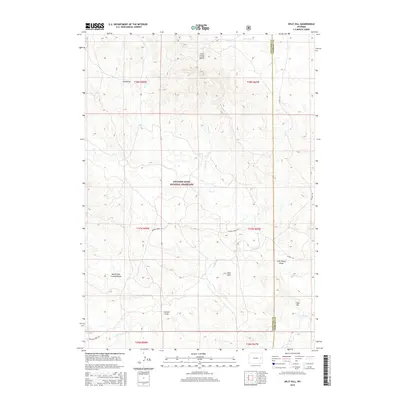
2015 Map of Split Hill
USGS Topo · Published 2015About this map
Thunder Basin National Grassland dominates this section of the High Plains, characterized by a complex network of seasonal drainages and prominent landmarks. The terrain is defined by the Cow Creek Buttes in the north and the namesake Split Hill near the center, highlighting the transition between rolling grassland and more pronounced landforms like Cake Hill. The drainage patterns are intricate, with Lightning Cr and Walker Cr carving through the landscape alongside numerous draws, including John Henry Draw and North Fork Crooked Draw. This 2015 survey illustrates a sparsely populated region of Converse County where transportation is limited to established routes such as Walker Creek Rd and K-Field Rd, which facilitate movement through this expansive rangeland environment.
Find a feature on this map
25 named features on this map. Tap any name to fly to it.
Don’t see what you’re looking for? This feature index may not catch every label — zoom into the map to look around manually.
Map Details
Editions of this 2015 Split Hill Map
This is the sole edition of this map. No revisions or reprints were ever made.
Other maps of this area

1955 · Newcastle
USGS Topo · 1:250,000

1958 · Newcastle
USGS Topo · 1:250,000

1970 · Bill 4 SE
USGS Topo · 1:24,000

1970 · Bill 4 NE
USGS Topo · 1:24,000

1971 · Esau Spring
USGS Topo · 1:24,000

1979 · Bill
USGS Topo · 1:100,000

1981 · Calf Draw
USGS Topo · 1:24,000

1981 · Mercer Draw
USGS Topo · 1:24,000

1981 · Pinnacle Rocks
USGS Topo · 1:24,000
1981 · Split Hill SW
USGS Topo · 1:24,000