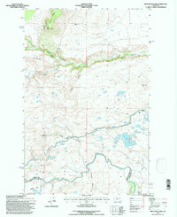
1995 Map of Split Rock Lake
USGS Topo · Published 1997About this map
Indian Burial Ground (Historical Site) marks a significant point of cultural history in this portion of the Montana landscape, located near the South Fork Deep Creek. The map documents a transition in land use along the borders of Teton and Lewis and Clark Counties, where several former homesteads such as Stetler Ranch (Aband) and Frazier Ranch (Aband) are noted as abandoned. The region's hydraulic development is centered on the Pishkun Canal, which feeds the large Pishkun Reservoir, illustrating the intensive management of water resources in an area otherwise characterized by natural features like Split Rock Lake and the Sun River. From the heights of Long Ridge to the lower reaches of Alkali Flat, the terrain is defined by dramatic geological features like Black Reef and the winding paths of Deep Creek and Battle Creek.
Find a feature on this map
22 named features on this map. Tap any name to fly to it.
Don’t see what you’re looking for? This feature index may not catch every label — zoom into the map to look around manually.
Map Details
Editions of this 1995 Split Rock Lake Map
This is the sole edition of this map. No revisions or reprints were ever made.
Other maps of this area

1903 · Saypo
USGS Topo · 1:125,000

1920 · Choteau
USGS Topo · 1:125,000

1955 · Choteau
USGS Topo · 1:250,000

1957 · Choteau
USGS Topo · 1:250,000

1958 · Choteau
USGS Topo · 1:250,000

1958 · Ear Mountain
USGS Topo · 1:24,000

1958 · Lake Theboe
USGS Topo · 1:24,000

1958 · Barr Creek
USGS Topo · 1:24,000

1958 · Sawtooth Ridge
USGS Topo · 1:24,000

1958 · Castle Reef
USGS Topo · 1:24,000