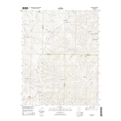
2015 Map of Spokane
USGS Topo · Published 2015About this map
Spokane and the village of Abesville occupy a transition in the Ozark landscape where the rolling plateaus of Christian County meet the more dissected hills of Stone County. The area is defined by a dendritic network of drainages, including the Bear Cr and W Fork Bear Cr systems, which have carved deep valleys like Hurricane Hollow and Pignut Hollow. Small, historic settlements such as Ponce de Leon, Tauria, and Stutts are scattered along the ridge tops and valley floors, connected by a web of local roads like Old Highway 160 and Daniel Rd. Genealogists and local historians will find significant value in the documentation of several rural burial grounds, including Schupbach Cemetery, Stutts Cemetery, and Seaton Cemetery, which serve as vital records of the families that settled these Missouri hills. The southern edge of the map features the northern outskirts of Reeds Spring, showing the continued importance of this corridor for regional travel and commerce.
Find a feature on this map
88 named features on this map. Tap any name to fly to it.
Don’t see what you’re looking for? This feature index may not catch every label — zoom into the map to look around manually.
Map Details
Editions of this 2015 Spokane Map
This is the sole edition of this map. No revisions or reprints were ever made.
Other maps of this area

1907 · Forsyth
USGS Topo · 1:125,000

1945 · Harrison
USGS Topo · 1:250,000

1949 · Harrison
USGS Topo · 1:250,000

1950 · Garber
USGS Topo · 1:24,000

1954 · Harrison
USGS Topo · 1:250,000
1955 · Selmore
USGS Topo · 1:24,000

1955 · Day
USGS Topo · 1:24,000
1955 · Hurley
USGS Topo · 1:24,000
1955 · Highlandville
USGS Topo · 1:24,000

1956 · Garber
USGS Topo · 1:24,000