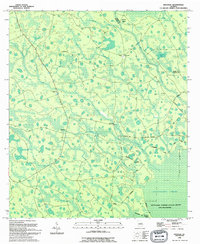
1994 Map of Spooner
USGS Topo · Published 1994About this map
Antioch Ch and a nearby Cem stand near the edge of the wetlands along the western side of this Clinch and Ware County border region. The landscape is defined by the expansive Okefenokee Swamp, which transitions from open water and marsh to elevated features like Gainey Island and Chopper Island. This 1994 revision shows the intricate network of drainage and creek systems, including Suwannee Creek, Goose Branch, and Big Mill Creek, which flow through the dense vegetation of the Okefenokee National Wildlife Refuge and Wilderness.
Find a feature on this map
25 named features on this map. Tap any name to fly to it.
Don’t see what you’re looking for? This feature index may not catch every label — zoom into the map to look around manually.
Map Details
Editions of this 1994 Spooner Map
This is the sole edition of this map. No revisions or reprints were ever made.
Other maps of this area

1953 · Waycross
USGS Topo · 1:250,000

1954 · Valdosta
USGS Topo · 1:250,000

1958 · Valdosta
USGS Topo · 1:250,000

1958 · Waycross
USGS Topo · 1:250,000

1959 · Valdosta
USGS Topo · 1:250,000

1966 · The Pocket
USGS Topo · 1:24,000

1966 · Cravens Island
USGS Topo · 1:24,000

1967 · Spooner
USGS Topo · 1:24,000

1967 · Colon
USGS Topo · 1:24,000

1967 · Waycross SW
USGS Topo · 1:24,000