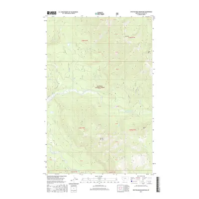
2017 Map of Spotted Bear Mountain
USGS Topo · Published 2017About this map
The Spotted Bear River winds through the heart of this high-elevation wilderness within the Flathead National Forest, meeting the South Fork Flathead River in the southwestern corner of the quadrangle. This 2017 survey documents a landscape defined by significant topographical relief, rising from the river valleys to prominent peaks such as Spotted Bear Mtn and Bent Mtn. A network of Forest Service roads, including F S 2850 Rd and F S 10132 Rd, provides limited access to the interior, while isolated water bodies like Webb Lake are tucked into the drainages. The map reveals the intricate drainage patterns of various tributaries, such as Twin Cr and Sergeant Cr, which have shaped the surrounding ridges like Green Mtn and Beaver Hill.
Find a feature on this map
37 named features on this map. Tap any name to fly to it.
Don’t see what you’re looking for? This feature index may not catch every label — zoom into the map to look around manually.
Map Details
Editions of this 2017 Spotted Bear Mountain Map
This is the sole edition of this map. No revisions or reprints were ever made.
Other maps of this area

1913 · Marias Pass
USGS Topo · 1:125,000

1914 · Nyack
USGS Topo · 1:125,000

1936 · Silvertip
USGS Topo · 1:96,000

1942 · Silvertip
USGS Topo · 1:125,000

1955 · Choteau
USGS Topo · 1:250,000

1957 · Choteau
USGS Topo · 1:250,000

1958 · Choteau
USGS Topo · 1:250,000

1958 · Capitol Mountain
USGS Topo · 1:24,000

1958 · Circus Peak
USGS Topo · 1:24,000

1958 · Horseshoe Peak
USGS Topo · 1:24,000