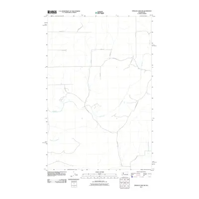
2011 Map of Sprague Lake SW
USGS Topo · Published 2011About this map
Crab Creek and its tributary, the South Fork Crab Creek, dictate the movement and settlement patterns across this high desert landscape of eastern Washington. This 2011 survey illustrates a sparse rural layout where the road network often bears the names of local families, suggesting a genealogy of land ownership tied to the area's agricultural development. Named routes such as Doerschlag Rd E, Stromberger Rd N, and Barbre Rd traverse the plateau, connecting isolated farmsteads to larger regional hubs. The drainage patterns of the creeks are the primary natural landmarks in an area otherwise defined by a systematic grid of section lines and local thoroughfares like Estate Rd N and E Arlt Rd, providing a clear look at modern rural infrastructure in Adams County.
Find a feature on this map
16 named features on this map. Tap any name to fly to it.
Don’t see what you’re looking for? This feature index may not catch every label — zoom into the map to look around manually.
Map Details
Editions of this 2011 Sprague Lake SW Map
This is the sole edition of this map. No revisions or reprints were ever made.
Other maps of this area

1953 · Ritzville
USGS Topo · 1:250,000

1959 · Ritzville
USGS Topo · 1:250,000

1964 · Karakul Hills
USGS Topo · 1:24,000

1964 · Palm Lake
USGS Topo · 1:24,000

1965 · Ritzville
USGS Topo · 1:250,000

1967 · Ritzville NE
USGS Topo · 1:24,000

1969 · Harrington
USGS Topo · 1:24,000

1969 · Sprague Lake
USGS Topo · 1:24,000

1969 · Lords Valley
USGS Topo · 1:24,000
1969 · Sprague Lake SW
USGS Topo · 1:24,000