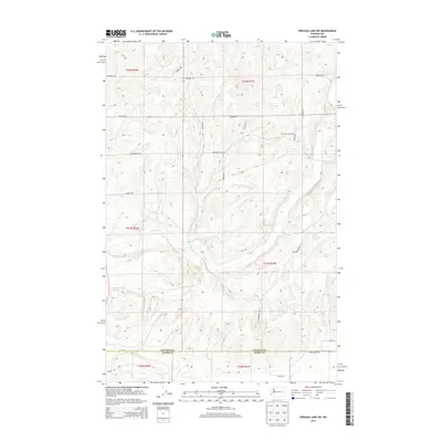
2013 Map of Sprague Lake SW
USGS Topo · Published 2013About this map
Crab Creek and its tributary, the S Fork Crab Cr, define the drainage patterns across this section of the Inland Empire. The landscape is structured by the Public Land Survey System, with section lines reflected in a grid of rural routes such as Everhart Rd, Doerschlag Rd E, and Stromberger Rd N. This territory straddles the Lincoln and Adams county line, where the terrain transitions from the upland plateaus toward the coulee-carved valley floors. The distribution of family-named roads like Bourne Rd N and Soden Rd N suggests the deep roots of agricultural landholdings in this part of Washington. Researchers can trace the intersection of water resources and transportation, observing how local paths like Larmer Rd E and Rolinco Rd E navigate the subtle shifts in elevation surrounding the creek beds.
Find a feature on this map
25 named features on this map. Tap any name to fly to it.
Don’t see what you’re looking for? This feature index may not catch every label — zoom into the map to look around manually.
Map Details
Editions of this 2013 Sprague Lake SW Map
This is the sole edition of this map. No revisions or reprints were ever made.
Other maps of this area

1953 · Ritzville
USGS Topo · 1:250,000

1959 · Ritzville
USGS Topo · 1:250,000

1964 · Karakul Hills
USGS Topo · 1:24,000

1964 · Palm Lake
USGS Topo · 1:24,000

1965 · Ritzville
USGS Topo · 1:250,000

1967 · Ritzville NE
USGS Topo · 1:24,000

1969 · Harrington
USGS Topo · 1:24,000

1969 · Sprague Lake
USGS Topo · 1:24,000

1969 · Lords Valley
USGS Topo · 1:24,000
1969 · Sprague Lake SW
USGS Topo · 1:24,000