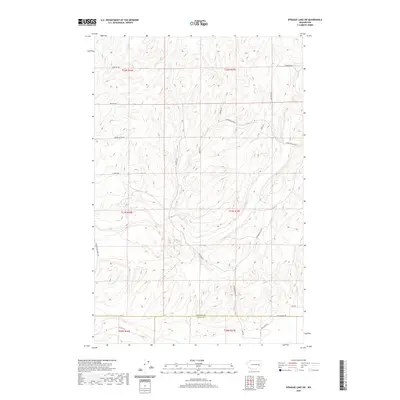
2020 Map of Sprague Lake SW
USGS Topo · Published 2020About this map
Crab Creek and its southern branch, S Fork Crab Cr, define the drainage patterns of this rural landscape where the high plateaus of Lincoln and Adams counties meet. The area is characterized by an organized grid of county roads that reflect the agricultural heritage of the region. Notable thoroughfares like the Harrington-Tokio Rd and Doerschlag Rd E connect dispersed farmsteads across several townships, including t21n r37e. The topography is defined by the coulee-like formations common to this part of Washington, where seasonal water flow in channels like Crab Cr has sculpted the terrain. This document captures the modern state of these rural corridors, showing the precise alignment of local routes such as Platter Rd N and Stromberger Rd N as they navigate the undulating elevation changes between the county line and the larger water systems to the north.
Find a feature on this map
27 named features on this map. Tap any name to fly to it.
Don’t see what you’re looking for? This feature index may not catch every label — zoom into the map to look around manually.
Map Details
Editions of this 2020 Sprague Lake SW Map
This is the sole edition of this map. No revisions or reprints were ever made.
Other maps of this area

1953 · Ritzville
USGS Topo · 1:250,000

1959 · Ritzville
USGS Topo · 1:250,000

1964 · Karakul Hills
USGS Topo · 1:24,000

1964 · Palm Lake
USGS Topo · 1:24,000

1965 · Ritzville
USGS Topo · 1:250,000

1967 · Ritzville NE
USGS Topo · 1:24,000

1969 · Harrington
USGS Topo · 1:24,000

1969 · Sprague Lake
USGS Topo · 1:24,000

1969 · Lords Valley
USGS Topo · 1:24,000
1969 · Sprague Lake SW
USGS Topo · 1:24,000