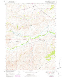
1949 Map of Spring Creek
USGS Topo · Published 1982About this map
Horseshoe Creek and its northern branch, North Horseshoe Creek, dominate this high-plains landscape in Platte County, where water resources dictated the pattern of ranching and early settlement. The terrain is marked by significant topographical relief, rising toward Deer Hill in the southwest and defined by deep incisions like Sand Draw and Reeder Draw. Published in 1982 with data from 1949 and late-seventies revisions, the sheet captures a transition toward modern energy infrastructure, evidenced by the prominent Pipe Line corridor cutting across the northern reaches near Whiskey Gulch. Scattered Windmills serve as vital landmarks for local history researchers, indicating specific points of long-term habitation and land use across this drainage-fed environment where Coyote Creek and Pollard Creek converge.
Find a feature on this map
15 named features on this map. Tap any name to fly to it.
Don’t see what you’re looking for? This feature index may not catch every label — zoom into the map to look around manually.
Map Details
Editions of this 1949 Spring Creek Map
2 editions found
Other maps of this area

1943 · Esterbrook
USGS Topo · 1:62,500

1945 · Esterbrook
USGS Topo · 1:62,500

1949 · Cedar Hill
USGS Topo · 1:24,000

1949 · Spring Creek
USGS Topo · 1:24,000

1949 · Dilts Ranch
USGS Topo · 1:24,000

1950 · Glendo
USGS Topo · 1:24,000

1950 · Spring Creek
USGS Topo · 1:24,000
1950 · Dilts Ranch
USGS Topo · 1:24,000

1950 · Coleman Butte
USGS Topo · 1:24,000

1950 · Cottonwood Falls
USGS Topo · 1:24,000