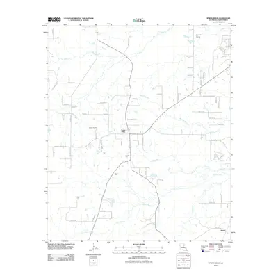
2012 Map of Spring Ridge
USGS Topo · Published 2012About this map
Spring Ridge and Preston anchor this portion of Caddo Parish, Louisiana, as it appeared in the early 21st century. The landscape is defined by the winding paths of Boggy Bayou, Buchanan Bayou, and Cypress Bayou, which carve through the terrain between low-lying drainages like Johnson Br and Foster Cr. The area’s industrial character is marked by energy extraction at the Metcalf Oil and Gas Field and Johnson Gas Field, alongside the significant footprint of the CQC Landfill. For local historians and genealogists, the map is an essential record of family burial grounds, preserving the locations of New Hill, Davidson Cem, Johnson Cem, Pollard Cem, and Hughes Cem. The road network, including the junction of Keithville Springridge Rd and Ridge Rd, connects these rural sites to larger thoroughfares like Woolworth Rd, reflecting the modern infrastructure overlaying a traditional Southern bayou landscape.
Find a feature on this map
88 named features on this map. Tap any name to fly to it.
Don’t see what you’re looking for? This feature index may not catch every label — zoom into the map to look around manually.
Map Details
Editions of this 2012 Spring Ridge Map
This is the sole edition of this map. No revisions or reprints were ever made.
Other maps of this area

1943 · Waskom
USGS Topo · 1:62,500

1945 · Grand Cane
USGS Topo · 1:62,500

1945 · Waskom
USGS Topo · 1:62,500

1945 · Greenwood
USGS Topo · 1:62,500

1945 · Socagee Bayou
USGS Topo · 1:62,500

1955 · Shreveport
USGS Topo · 1:250,000
1955 · Shreveport West
USGS Topo · 1:24,000

1955 · Greenwood
USGS Topo · 1:62,500

1956 · Shreveport
USGS Topo · 1:250,000

1956 · Tyler
USGS Topo · 1:250,000