
1918 Map of Spring Valley
USGS Topo · Published 1918About this map
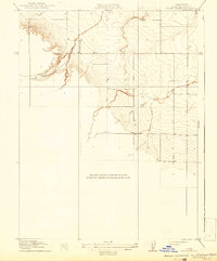
Spring Valley is defined by its complex drainage network, where the Spring Valley Creek and several distinct forks carve through the Colusa County terrain. This 1918 Preliminary Edition reflects a landscape at the transition between the valley floor and more varied topography, surveyed originally in 1905 by topographic teams including C.H. Birdseye and C.L. Nelson. The naming of Old Cortina Creek alongside its South Fork suggests an established system of seasonal or perennial waterways that dictated local land use long before modern irrigation changed the Central Valley's water management. The area shows little in the way of built infrastructure, focusing instead on the natural features like Chamisal Creek and the South Fork, which provided the necessary water sources for early ranching and agricultural operations in this part of California.
Find a feature on this map
7 named features on this map. Tap any name to fly to it.
Don’t see what you’re looking for? This feature index may not catch every label — zoom into the map to look around manually.
Map Details
Editions of this 1918 Spring Valley Map
2 editions found
Other maps of this area

1905 · Harrington
USGS Topo · 1:24,000

1905 · Fairview
USGS Topo · 1:24,000

1907 · Colusa
USGS Topo · 1:62,500

1916 · Harrington
USGS Topo · 1:31,680

1918 · Williams
USGS Topo · 1:31,680
1918 · Arbuckle
USGS Topo · 1:31,680
1918 · Powell Slough
USGS Topo · 1:31,680

1920 · Venado
USGS Topo · 1:62,500

1942 · Colusa
USGS Topo · 1:62,500

1943 · Morgan Valley
USGS Topo · 1:62,500