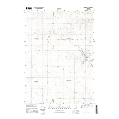
2016 Map of Spring Valley
USGS Topo · Published 2016About this map
Spring Valley occupies the eastern portion of this quadrangle, where a grid of streets like S Broadway Ave and W Park St meets the winding course of Spring Valley Cr. This area of Fillmore and Mower counties is defined by its drainage systems, with the S Br Root River cutting across the southern sections while Deer Cr and Little Kingsley Cr traverse the northern landscape. Local history is anchored by several burial grounds, including the centrally located Frankford Cem and the Saint Ignatius Cem on the town's outskirts. Caldbeck Field sits along the western approach to the settlement, marking a shift from the agrarian townships of t103n r13w to the more concentrated residential and commercial blocks of the village center.
Find a feature on this map
62 named features on this map. Tap any name to fly to it.
Don’t see what you’re looking for? This feature index may not catch every label — zoom into the map to look around manually.
Map Details
Editions of this 2016 Spring Valley Map
This is the sole edition of this map. No revisions or reprints were ever made.
Other maps of this area

1954 · Mason City
USGS Topo · 1:250,000
1955 · Stewartville
USGS Topo · 1:62,500
1955 · High Forest
USGS Topo · 1:62,500

1957 · Mason City
USGS Topo · 1:250,000

1958 · Mason City
USGS Topo · 1:250,000
1965 · Le Roy
USGS Topo · 1:24,000
1965 · Wykoff
USGS Topo · 1:24,000
1965 · Spring Valley
USGS Topo · 1:24,000
1965 · Grand Meadow
USGS Topo · 1:24,000
1965 · Ostrander
USGS Topo · 1:24,000