
1965 Map of Wykoff
USGS Topo · Published 1966About this map
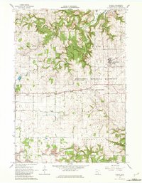
The village of Wykoff serves as the primary hub in this mid-1960s survey, situated along the Chicago Milwaukee St Paul and Pacific railroad line. This agricultural landscape in Fillmore County is defined by its deep limestone geography, evidenced by the presence of Pine Tree Cave and Forestville Cave. The region transitions from the open fields of Bloomfield and Spring Valley townships into the wooded coulees of the Minnesota Memorial Hardwood State Forest, where the South Branch Root River winds through the southeastern corner.
Find a feature on this map
39 named features on this map. Tap any name to fly to it.
Don’t see what you’re looking for? This feature index may not catch every label — zoom into the map to look around manually.
Map Details
Editions of this 1965 Wykoff Map
2 editions found
Other maps of this area

1954 · Chatfield
USGS Topo · 1:62,500

1954 · Mason City
USGS Topo · 1:250,000

1955 · Stewartville
USGS Topo · 1:62,500

1957 · Mason City
USGS Topo · 1:250,000

1958 · Mason City
USGS Topo · 1:250,000

1965 · Greenleafton
USGS Topo · 1:24,000

1965 · Spring Valley
USGS Topo · 1:24,000

1965 · Ostrander
USGS Topo · 1:24,000

1965 · Fountain
USGS Topo · 1:24,000

1965 · Cherry Grove
USGS Topo · 1:24,000