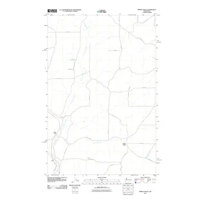
2011 Map of Spring Valley
USGS Topo · Published 2011About this map
Spring Valley and the surrounding agricultural lands of southern Spokane County are captured here in a 2011 survey by the U.S. Geological Survey. The landscape is defined by the convergence of several drainages, most notably North Pine Creek and Spring Valley Creek, which create a network of draws and valleys among the rolling terrain. The map records several small settlement points, including the namesake Spring Valley and North Pine, while highlighting the transition of historical transit corridors into recreational use with the John Wayne Trl following the old rail grade in the southwest. Local history is anchored by Rosalia Cemetery near the southern border. The road network, including names like Kentuck Trails Rd and S North Pine Creek Rd, follows the section lines and natural contours of this rural landscape.
Find a feature on this map
32 named features on this map. Tap any name to fly to it.
Don’t see what you’re looking for? This feature index may not catch every label — zoom into the map to look around manually.
Map Details
Editions of this 2011 Spring Valley Map
This is the sole edition of this map. No revisions or reprints were ever made.
Other maps of this area

1903 · Oakesdale
USGS Topo · 1:125,000

1905 · Oakesdale
USGS Topo · 1:125,000

1954 · Spangle
USGS Topo · 1:62,500

1954 · Fairfield
USGS Topo · 1:62,500

1955 · Spokane
USGS Topo · 1:250,000

1958 · Spokane
USGS Topo · 1:250,000

1964 · Oakesdale
USGS Topo · 1:24,000

1964 · Malden
USGS Topo · 1:24,000
1964 · Rosalia
USGS Topo · 1:24,000
1980 · Fairfield
USGS Topo · 1:24,000