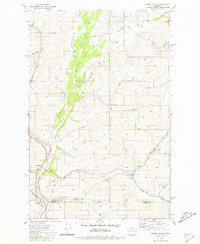
1980 Map of Spring Valley
USGS Topo · Published 1981About this map
The rolling agricultural landscape of eastern Washington is defined here by the winding course of North Pine Creek and the legacy of the Pacific Northwest rail network. This survey, revised in the late 1970s, captures the rural intersection of Spokane and Whitman counties just before significant changes in regional rail operations. The settlement of North Pine serves as a focal point along the Burlington Northern corridor, illustrating the area's historical reliance on rail for transporting the region's grain and timber. The terrain is marked by numerous gravel pits and small water bodies like Muskwat Lake, reflecting a landscape shaped by both natural drainage and local resource extraction.
Find a feature on this map
1 named feature on this map. Tap any name to fly to it.
Don’t see what you’re looking for? This feature index may not catch every label — zoom into the map to look around manually.
Map Details
Editions of this 1980 Spring Valley Map
This is the sole edition of this map. No revisions or reprints were ever made.
Other maps of this area

1903 · Oakesdale
USGS Topo · 1:125,000

1905 · Oakesdale
USGS Topo · 1:125,000

1954 · Spangle
USGS Topo · 1:62,500

1954 · Fairfield
USGS Topo · 1:62,500

1955 · Spokane
USGS Topo · 1:250,000

1958 · Spokane
USGS Topo · 1:250,000

1964 · Oakesdale
USGS Topo · 1:24,000

1964 · Malden
USGS Topo · 1:24,000
1964 · Rosalia
USGS Topo · 1:24,000
1980 · Fairfield
USGS Topo · 1:24,000