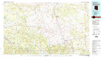
1981 Map of Springerville
USGS Topo · Published 1982About this map
The Mogollon Rim defines the dramatic southern geography of this 1980s landscape, marking the transition from the high plateau to the timbered reaches of the Fort Apache Indian Reservation. In the valley of the Little Colorado River, the twin communities of Springerville and Eagar serve as the central hub for a region defined by extensive public lands, including the Sitgreaves National Forest and Apache National Forest.
Find a feature on this map
65 named features on this map. Tap any name to fly to it.
Don’t see what you’re looking for? This feature index may not catch every label — zoom into the map to look around manually.
Map Details
Editions of this 1981 Springerville Map
2 editions found
Other maps of this area

1886 · St Johns
USGS Topo · 1:250,000

1886 · Holbrook
USGS Topo · 1:250,000

1892 · St Johns
USGS Topo · 1:250,000

1893 · Holbrook
USGS Topo · 1:250,000

1915 · Reserve
USGS Topo · 1:125,000

1918 · Reserve
USGS Topo · 1:125,000

1922 · Nutrioso
USGS Topo · 1:125,000

1954 · Holbrook
USGS Topo · 1:250,000

1954 · Clifton
USGS Topo · 1:250,000

1954 · Saint Johns
USGS Topo · 1:250,000