
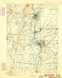
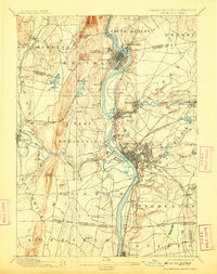
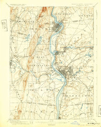
1895 Map of Springfield
USGS Topo · Published 1895About this map
The Connecticut River serves as the industrial and geographic spine of this region during the late nineteenth century, dividing established manufacturing centers and growing rail hubs. In Holyoke, the river’s power is harnessed via a complex canal system near South Hadley Falls, while the dense grid of Springfield expands outward toward Brightwood and Merrick. The map reveals the intricate network of the Boston & Albany RR and the New York New Haven & Hartford RR, which facilitated the rapid growth of industrial satellite settlements like Chicopee Falls and Indian Orchard. Beyond the urban centers, the landscape transitions to the agricultural and communal life of the Feeding Hills and the Shakers settlement near the Connecticut state border. Smaller hamlets such as Ireland Parish and Baptist provide evidence of earlier village identities that were increasingly integrated into the expanding regional economy.
Find a feature on this map
103 named features on this map. Tap any name to fly to it.
Don’t see what you’re looking for? This feature index may not catch every label — zoom into the map to look around manually.
Map Details
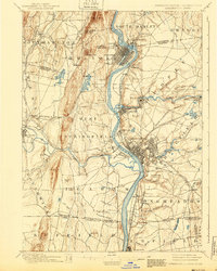
Editions of this 1895 Springfield Map
11 editions found
1895 edition
15.8 x 19.9 inches
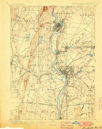
1900 edition
15.8 x 19.8 inches
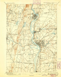
1903 edition
15.8 x 19.9 inches
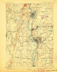
1905 edition
15.8 x 19.8 inches
1907 edition
15.7 x 20 inches
1909 edition
15.7 x 19.9 inches
1912 edition
15.8 x 19.8 inches
1917 edition
15.7 x 20.1 inches
1924 edition
15.8 x 19.8 inches
1932 edition
15.7 x 19.7 inches
1940 edition
15.8 x 19.7 inches
Other maps of this area

1885 · Northampton
USGS Topo · 1:62,500

1886 · Springfield
USGS Topo · 1:62,500

1886 · Chesterfield
USGS Topo · 1:62,500

1886 · Northampton
USGS Topo · 1:62,500

1887 · Palmer
USGS Topo · 1:62,500

1887 · Belchertown
USGS Topo · 1:62,500

1887 · Granville
USGS Topo · 1:62,500

1888 · Chesterfield
USGS Topo · 1:62,500

1889 · Springfield
USGS Topo · 1:62,500

1889 · Palmer
USGS Topo · 1:62,500