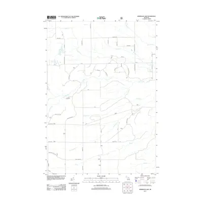
2012 Map of Sprinkler Lake
USGS Topo · Published 2012About this map
Sprinkler Lake and Delap Lake sit at the western edge of this Alcona County landscape, where the headwaters of numerous creeks begin their descent through the drainage basin of the Pine River. The northern terrain is defined by a dense network of tributaries including McGillis Cr and Gimlet Cr, while the southern reaches are marked by the steady flow of Vandercook Cr and Roy Cr. The road system follows a traditional grid pattern typical of Michigan's forested interior, with major local routes like W Mikado-Glennie Rd and Kings Corner Rd providing access to the more secluded areas near the Pine River Campground. This map documents a quiet, water-rich environment just as modern forestry and recreation patterns were firmly established in the region.
Find a feature on this map
45 named features on this map. Tap any name to fly to it.
Don’t see what you’re looking for? This feature index may not catch every label — zoom into the map to look around manually.
Map Details
Editions of this 2012 Sprinkler Lake Map
This is the sole edition of this map. No revisions or reprints were ever made.
Other maps of this area

1954 · Tawas City
USGS Topo · 1:250,000

1958 · Tawas City
USGS Topo · 1:250,000

1959 · Tawas City
USGS Topo · 1:62,500

1959 · East Tawas
USGS Topo · 1:62,500

1959 · Glennie
USGS Topo · 1:62,500

1959 · Harrisville
USGS Topo · 1:62,500

1983 · Hubbard Lake
USGS Topo · 1:100,000

1984 · Tawas City
USGS Topo · 1:100,000
1989 · Barton City
USGS Topo · 1:24,000

1989 · Mikado
USGS Topo · 1:24,000