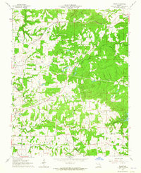
1964 Map of Sprott
USGS Topo · Published 1965About this map
The settlement of Sprott and the surrounding rural landscape of Ste. Genevieve County are defined by a network of creek drainages and small-scale social institutions in the early 1960s. The Missouri Illinois railroad corridor cuts through the northern section of the map, passing by Millers and crossing Establishment Creek. This area shows a dense concentration of family and community landmarks, particularly along the county line shared with St. Francois County. Genealogists will find a significant number of burial sites, including Chestnut Ridge Cem, Oakland Cem, McGee Cem, and Murphy Cem. Educational and religious life is anchored by locations such as Chestnut Ridge Sch, Busiek Sch, and Genevieve Ch. The topography is shaped by the winding paths of Jonca Creek, the North Fork, and Pickle Creek, which feed into the larger waterway of River aux Vases near Butterfly Lake.
Find a feature on this map
31 named features on this map. Tap any name to fly to it.
Don’t see what you’re looking for? This feature index may not catch every label — zoom into the map to look around manually.
Map Details
Editions of this 1964 Sprott Map
2 editions found
Other maps of this area

1904 · Farmington
USGS Topo · 1:62,500

1906 · Farmington
USGS Topo · 1:62,500

1907 · Weingarten
USGS Topo · 1:62,500

1909 · Weingarten
USGS Topo · 1:62,500

1910 · Higdon
USGS Topo · 1:62,500

1939 · Fredericktown
USGS Topo · 1:48,000

1947 · Fredericktown
USGS Topo · 1:62,500

1949 · Rolla
USGS Topo · 1:250,000

1950 · Fredericktown
USGS Topo · 1:62,500

1953 · Rolla
USGS Topo · 1:250,000