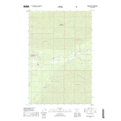
2020 Map of Spruce Mountain
USGS Topo · Published 2020About this map
Huelsdonk Bridge spans the Hoh River in this western Olympic Peninsula landscape, where industrial logging access meets protected wilderness. The geography is defined by the sharp rise from the river valley toward Spruce Mtn and Huelsdonk Ridge, reflecting the region's intense topographic relief. Transport in this era relies on a network of forest roads and historic paths, including Rain Forest Rd and the S Snyder-Jackson Primitive Trail, which navigates the high country near Geodetic Hill. The division between the Olympic National Park and the Olympic National Forest is clearly delineated, illustrating the management of these coastal woodlands. Dozens of drainages such as Dismal Cr, Tower Cr, and Tumwater Cr feed the river system, carving deep into the timberlands of the Hoh valley.
Find a feature on this map
38 named features on this map. Tap any name to fly to it.
Don’t see what you’re looking for? This feature index may not catch every label — zoom into the map to look around manually.
Map Details
Editions of this 2020 Spruce Mountain Map
This is the sole edition of this map. No revisions or reprints were ever made.
Other maps of this area

1939 · Mount Tom
USGS Topo · 1:62,500

1943 · Spruce Mountain
USGS Topo · 1:62,500

1943 · Copalis Beach
USGS Topo · 1:250,000

1950 · Slide Peak
USGS Topo · 1:24,000

1951 · Copalis Beach
USGS Topo · 1:250,000

1956 · Kloochman Rock
USGS Topo · 1:62,500

1956 · Mount Tom
USGS Topo · 1:62,500

1956 · Spruce Mtn.
USGS Topo · 1:62,500

1956 · Salmon River
USGS Topo · 1:62,500
1957 · Mount Tom
USGS Topo · 1:62,500